Monday, December 28, 2009

Classical Egypt

Atlas of Egyptian Art


Histoire de l'art égyptien by Prisse D'Avennes, 1878 b

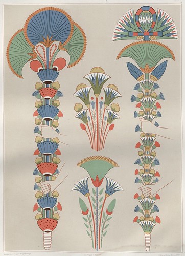
Stylised bouquets painted in tombs during the 19th and 20th Dynasties.


[nb. Wiki: map and history of ancient Egypt]


Histoire de l'art égyptien by Prisse D'Avennes, 1878 l

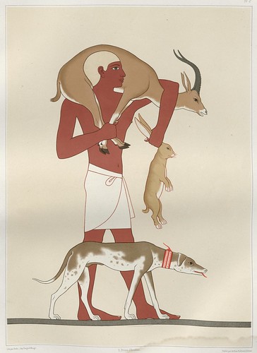
Return from the Hunt - from a painting at the Theban Necropolis (17th Dynasty)


Histoire de l'art égyptien by Prisse D'Avennes, 1878 m

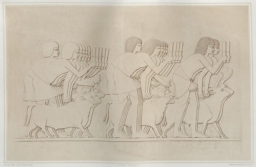
Counting the oxen - drawing of a bas-relief found in the tomb of Chamhati,
the superintendent of the royal domains during the 18th dynasty


Histoire de l'art égyptien by Prisse D'Avennes, 1878 n

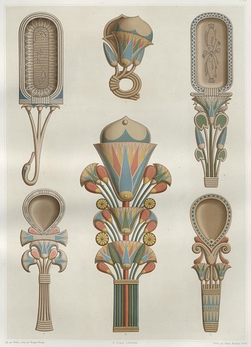
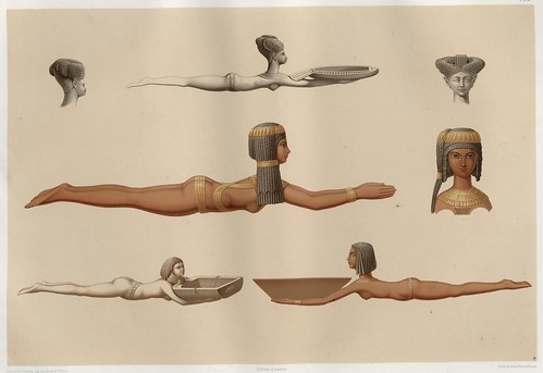
?Perfume containers and grooming utensils


Histoire de l'art égyptien by Prisse D'Avennes, 1878 o

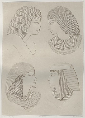
Profile portraits drawn from bas-relief figures at the Necropolis of Thebes.


Histoire de l'art égyptien by Prisse D'Avennes, 1878 a

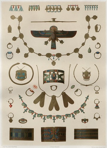
Necklaces, bangles, rings and jewellery segments from various periods


Histoire de l'art égyptien by Prisse D'Avennes, 1878 i

A hunter returns to his barge - from a 12th Dynasty tomb painting
(2100-1900BC) at the cemetery of Beni Hasan*


Histoire de l'art égyptien by Prisse D'Avennes, 1878 e

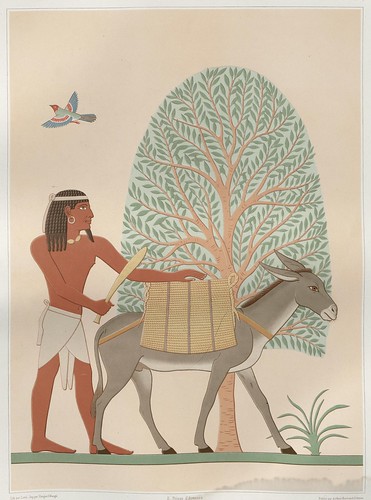
A native from the fabled and mysterious Land Of Punt carries goods on an ass
- from a painting found in the ?valley of El-Assacif at Thebes


Histoire de l'art égyptien by Prisse D'Avennes, 1878 c

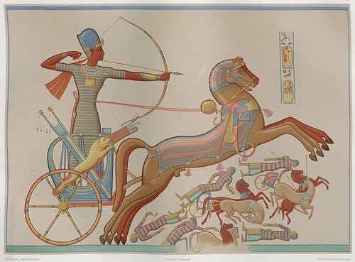
By the banks of the Orontes river, King Ramses II (Ramses-Meiamoun or Ozymandius* or Ramesses the Great, the third ruler of the XIXth dynasty and considered the most powerful Pharaoh of all) battles the Hittites (Khetas) from his chariot. Although not stated, this illustration presumably derives from a sculpture or bas-relief at the Ramesses II temple at Abu Simbel in Nubia.


Histoire de l'art égyptien by Prisse D'Avennes, 1878 d

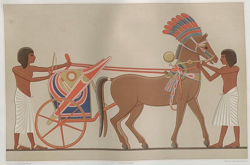
The Prince's chariot - from a sculpture at el-Amarna [Akhetaten] (300km south of Cairo)*; "..established and built by the Pharaoh Akhenaten of the late Eighteenth Dynasty (c. 1353 BC), and abandoned shortly afterwards.."


Histoire de l'art égyptien by Prisse D'Avennes, 1878 f

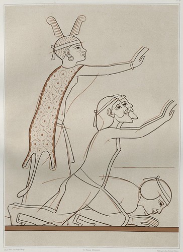
Sketch (of a sketch) of ?purification ritual foreigners prostrating before the Pharaoh from the Necropolis at Thebes


Histoire de l'art égyptien by Prisse D'Avennes, 1878 g

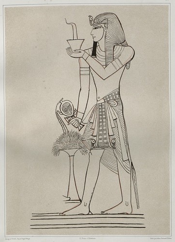
Sketch of Seti I, father of Ramses II from the Necropolis at Thebes


Histoire de l'art égyptien by Prisse D'Avennes, 1878 h

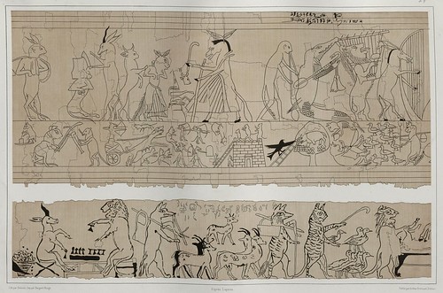
Satirical anthropomorphic 'cartoons' from an ancient Egyptian papyrus manuscript


Histoire de l'art égyptien by Prisse D'Avennes, 1878 j

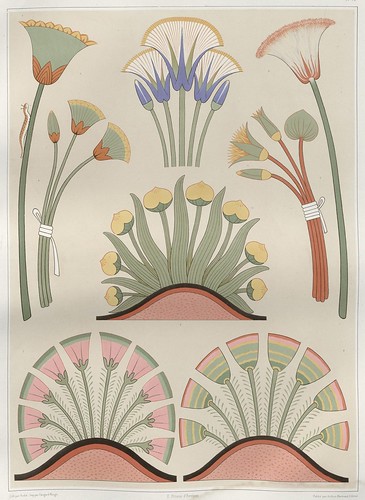
Flowers and plants derived from various monuments
[I've posted parts of a similar image before]


Histoire de l'art égyptien by Prisse D'Avennes, 1878

Painted wooden spoons and perfume vessels featuring
female figures of contrasting ethnicities or rank (or both)


Histoire de l'art égyptien by Prisse D'Avennes, 1878 k

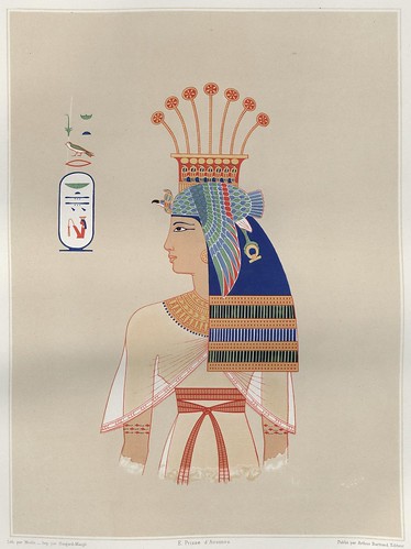
Portrait of Queen Nebto, daughter of Ramesses II (19th dynasty)


Histoire de l'art égyptien by Prisse D'Avennes, 1878 p

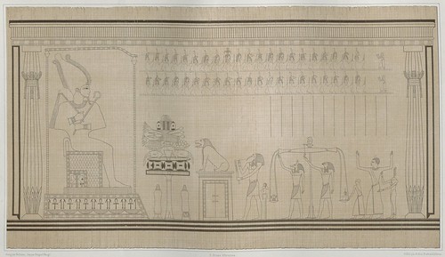
Weighing and judgement of the soul during
a funerary ritual at the court of Osiris (18th dynasty)


[click through for full-sized versions;
all these chromolithographs were cropped from full-page illustrations]


Émile Prisse d'Avesnes (d'Avennes) (1807-1879) was an important mid-19th century French Egyptologist and something of a polymath. He was a soldier, engineer, writer, illustrator and talented linguist.

From 1827 to 1844 d'Avesnes resided in Egypt, teaching cartography and working as an engineer for a time, but eventually he devoted himself to documenting and studying the archaeological treasures from ancient Egypt. He became proficient in hieroglyphs, on the back of Champollion's translations of the Rosetta Stone, and learned to speak at least half a dozen languages fluently during his expeditions around Egypt and further afield in the Arab world.

Ransacking of the artefacts was rife in those days of course and d'Avesnes helped excavate and transfer a large shipment of portrait reliefs from the Valley of the Kings to France, ostensibly to prevent their theft and use as local building material. The brazen act would earn d'Avesnes the Legion of Honour award when he returned to his homeland.

He published a number of Egypt-centric works in the decade following his return to France and eventually set about obtaining support for a further expedition which was undertaken from 1858 to 1860. On this occasion he was accompanied by a photographer (the photographs are now located in the French National Library).
"When he returned to Paris in I860; Prisse brought 300 folio drawings of paintings of various epochs, each up to seven or eight meters (23 to-26 feet) long; 400 meters (1300 feet) of paper impressions of bas-reliefs; 150 photographs of architectural and ornamental details, plans,sections and elevations; and 150 stereoscopic photographs, together with his enormous collection of drawing and notes. He also brought back, and later donated to the Louvre, the skulls of 29 mummies which he had identified by era, position and individual name." [source]

The most important of d'Avesnes' publications -- the subject of this post -- was released in installments over ten years and eventually compiled into a three volume work (one text and two illustrated atlases) in 1878 entitled: 'Histoire de l'Art Égyptien: d'après les Monuments; Depuis les Temps les Plus Reculés Jusqu'à la Domination Romaine' (~The history of Egyptian art from monuments from the earliest times up to Roman occupation).

Wednesday, December 23, 2009

A Bug's Life

Classis II Papilionum Noctornum (Bomcyx gini) V.1


Classis I Papilionum Noctornum (Sphinx convolvule) V.1


Bomcyx pavonia V.4


Classis I Papilionum Noctornum (Bomcyx salicis) V.1


Classis I Papilionum Noctornum (Noctua nupta) V.1


Classis I Papilionum Noctornum (Sphinx elpenor) V.1


Classis II Papilionum Noctornum (Bomcyx fascelina) V.1


Classis II Papilionum Noctornum (Bomcyx quercifolia) V.1


Scarabaeorum terrestrium Classis I V.2 a


Locusta Indica V.2 a


Helicoma spp + beetle V4


Insectorum aquatilium Classis II V.2


Locusta germanica V.2 a


Locusta germanica V.2


Locusta germanica V.2 b


Locusta Indica praefat V.2 a


Locusta Indica praefat V.2


Locusta Indica V.2


Locusta V.2 a


Locusta V.2 b


Locusta V.2


Pieris elathea + Colias philea etc V.4


Scarabaeorum terrestrium Classis I V.2


Scarabaeorum terrestrium praefat (dissected) V.4


Scarabaeorum terrestrium praefat Classis I V.4


Spider webs


Spiders dissected V.4


Spiders V.4


Insecten-Belustigung V.1 frontispiece


Insecten-Belustigung V.2 frontispiece


"August Johann Rösel von Rosenhof (1705-1759) was a German descendent of Austrian nobility and showed an early aptitude for painting. Following an apprenticeship with his artist-uncle and further study at the Academy of Nuremberg, Rösel obtained an appointment at the royal court in Copenhagen painting portraits and miniatures." [continues in a previous Rosenhof post: Ranarum Nostratium]

Three volumes from 'Insecten-Belustigung' (Insect Amusements) by AJ Rösel von Rosenhof are available from the University of Heidelberg (click through and look for 'Vorschau' = thumbnails). The books were released in installments between 1746 and 1761.


A happy and safe religious/irreligious/silly season to all!

Monday, December 21, 2009

Victorian Infographics

A Time Table (Mitchell's New General Atlas) 1864

A time table indicating the difference in time between the principal cities of the World and also showing their air-line distance from Washington.

IN: 'Mitchell's New General Atlas, Containing Maps Of The Various Countries Of The World, Plans Of Cities, Etc., Embraced In Ninety-Three Quarto Maps, Forming A Series Of One Hundred and Forty-seven Maps and Plans, Together With Valuable Statistical Tables..' by Samuel Augustus Mitchell Jr, 1883; published in Philadelphia by WM Bradley.


'Tableau d'Astronomie et de sphère' by Henri Duval, 1834

Tableau d'Astronomie et de Sphère

IN: 'Atlas Universel d'Histoire et de Geographie Anciennes et Modernes, de Mythologie, des Religions, d'Astronomie, de Physique, de Geologie, de Histoire Naturelle, de Grammaire, de Rhetorique..' by Henri Duval, 1834; published in Paris by L Houbloup.


'Tableau d'Astronomie et de sphère' by Henri Duval, 1834 (detail)

Tableau d'Astronomie et de Sphère [detail]


Theory of the Seasons + Comparative Planetary Sizes

The Solar System. Theory of the Seasons.


IN: 'General Atlas Of The World: Containing Upwards Of Seventy Maps. Engraved On Steel, In The First Style Of Art, By Sidney Hall, William Hughes, F.R.G.S., &c. New Edition. Embracing All The Latest Discoveries Obtained From Government Surveys And Expeditions, Books Of Recent Travel, And Other Sources, Including The North-West Passage Discovered By H.M. Ship Investigator. With Introductory Chapters On The Geography And Statistics Of The Various Countries Of The World, And A Complete Index Of 65,000 Names' by Adam & Charles Black, Sidney Hall and William Hughes, 1854; published in Edinburgh by A & C Black.


celestial hemispheres

Northern Celestial Hemisphere. Southern Celestial Hemisphere.

IN: 'General Atlas Of The World: Containing Upwards Of Seventy Maps...{as above}' by Adam & Charles Black, Sidney Hall and William Hughes, 1854; published in Edinburgh by A & C Black.


Tableau d'histoire naturelle Annelides, Crustaces, Arachnides, etc, 1834

Tableau d'Histoire Naturelle: Annelides, Crustaces, Arachnides, etc.

IN: 'Atlas Universel d'Histoire et de Geographie anciennes et modernes, de Mythologie, des Religions, d'Astronomie, de Physique, de Geologie, de Histoire naturelle, de Grammaire, de Rhetorique &..' by Henri Duval, 1834; published in Paris by L Houbloup


Tableau d'histoire naturelle Annelides, Crustaces, Arachnides, etc, 1834 (detail)

Tableau d'Histoire Naturelle: Annelides, Crustaces, Arachnides, etc. (detail)


Tableau de L'Histoire Universelle 1858

Tableau De L'Histoire Universelle depuis la Creation jusqu'a ce jour

This is a fold-out print depicting all of human history from the time of creation (4693 BC = Adam & Eve; the great flood = 3300 BC) up to the date of publication (1858 by Eug. Pick, Paris). Vignettes of historically significant people, places and buildings etc are arranged along the borders.

This audacious document mirrors the style of a similar graphical print by Colton from 1842 [I don't think it's online] and is in the same ballpark as an 1836 chart by Emma Willard (see here).

The designer has employed something of a metaphorical display choice: civilisations are presented as a series of rivers -- the widths likely imply the comparative population level of each group versus the world's population -- which 'flow' down through history.


World physical and ethnological charts

Chart of the World Exhibiting Its Chief Physical Features. Currents of the Ocean &c. Ethnographic Chart of the World Shewing (sic) the Distribution and Varieties of the Human Race.

IN: 'General Atlas Of The World: Containing Upwards Of Seventy Maps...{as above}' by Adam & Charles Black, Sidney Hall and William Hughes, 1854; published in Edinburgh by A & C Black.


19th century topographic map of NYC

Topographical Atlas Of The City Of New York Including The Annexed Territory. Showing original water courses and made land.

[click here for a VERY large version - the version at the source site is two or three times as large again: the downloadable MrSID file is ~50Mb which converts to a 270+ Mb jpeg file--> source]


Another stand-alone print, produced by J Bien & EL Viele in 1874 (by photolithography).
"Includes graphic scale. Streets named, ferry routes shown, railroads, streamcourses designated, and topography shown by hachures. Lands designated as originally meadow or marsh, or water as shown as made (filled) lands. Includes Manhattan and the Bronx and adjacent islands. Shows three cross-sections: across Central Park, from 50th Street to Brooklyn Heights, and from Hoboken to Brooklyn."


Geological Map of the State of Pennsylvania 1858

Geological Map Of The State Of Pennsylvania

'Geological Map Of The State Of Pennsylvania, Constructed From Original Surveys Made between the Years 1836 and 1857, Under The Superintendence Of Henry D. Rogers, State Geologist. To Accompany the Final Report on the Geological Survey of the State 1858. Entered ... 1858 by Henry D. Rogers ... Pennsylvania. Engraved by W. & A.K. Johnston Edinburgh.'

The different colours refer to the various geological types (coal = grey shades for instance). The bottom of the chart includes cross-sectional geological views of numerous land tracts. Regrettably, this is the only chart among the selection in this post for which the MrSID file wasn't available. [UPDATE 6.1.10 - the mrSID image is now available from the bottom of the sidebar HERE] So, although you can click through to a fairly large original image above, it's not really big enough to view the details as well as one might like [but they will be if you go and grab the {enormous} mrSID!].


Geological Map of the State of Pennsylvania 1858 (detail)

Geological Map Of The State Of Pennsylvania [detail]


Humboldt's Distribution of Plants in Equinoctial America, 1854

Humboldt's Distribution of Plants in Equinoctial America

IN: 'General Atlas Of The World: Containing Upwards Of Seventy Maps...{as above}' by Adam & Charles Black, Sidney Hall and William Hughes, 1854; published in Edinburgh by A & C Black.

Alexander von Humboldt's original (and exceptionally clever, for the time) botanical elevation distribution map of Ecuador's Mount Chimborazo appeared in the first decade of the 19th century [see: here/here and wiki. Humboldt is the first of my heroes to be mentioned in this post.]


East and West Hemispheres - globe maps and comparative mountains + river schematics

Eastern and Western Hemispheres (two separate pages joined for this image)

IN: 'Mitchell's New General Atlas, Containing Maps Of The Various Countries Of The World, Plans Of Cities, Etc., Embraced In Ninety-Three Quarto Maps, Forming A Series Of One Hundred and Forty-seven Maps and Plans, Together With Valuable Statistical Tables..' by Samuel Augustus Mitchell Jr, 1883; published in Philadelphia by WM Bradley.

Includes inset drawings at the top showing comparative river lengths and mountain heights plus inset globe maps of the greatest masses of water and depictions of the southern and northern hemispheres at the the bottom.


Comparative Geography (mountains + rivers), 1854

Tinted drawing showing the comparative lengths of rivers and heights of mountains worldwide. The first text page in this volume has the legend for this sheet.

IN: 'General Atlas Of The World: Containing Upwards Of Seventy Maps...{as above}' by Adam & Charles Black, Sidney Hall and William Hughes, 1854; published in Edinburgh by A & C Black.


***Be sure to check out the River Deep Mountain High post from last year for lots more comparative graphics from the 19th century.***

-----------------------------------------------


The David Rumsey Map Collection has now been online for ten years. The above selection of carto-curios is from the latest batch of material uploaded to the site.

Rumsey is an internet hero of the first order. Following the success of his business he was able to afford to indulge his latent interest for all things cartographic and he assembled a massive collection of more than 150,000 items.

That might have been the end of the story: rich dude spends money on secret passion in obscurity. But Rumsey wanted to share his collection with the world and mere donation of his maps and atlases to a document repository didn't seem like it would fully satisfy his magnanimous urges. From a five year old interview on SFGate:
"I realized that whichever institution I gave it to would lock it away, put it on a shelf," he says, with mild indignation. "But just then the technology came along that would enable me to put it all up online, and it was obvious that this was the best way I could give it away to the public."

The site has been in continual development since. Every nine or twelve months a new cache of maps is added and the delivery system has been upgraded and optimised to a point where the site offers an exceptional model for how large-scale digitisation collections can be hosted and served in multiple formats in a very user-friendly manner.

So it goes that the most recent incarnation of the site is now live and is joined by a new blog (here's the announcement post about the newly available material) together with a twitter feed and facebook page.