

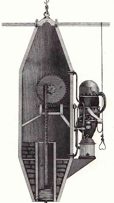
I *think* the top picture shows the crude breathing device made by Sieur Freminet in 1771. Unfortunately it was a closed rebreathing system and he died after 20 minutes under water from a lack of oxygen. [
Later: the origin of that picture is a mystery. It's not
Freminet. The
citing about Freminet's death pretty well contradicts the description in the french article below, which attests to his diving over a 10 year period using the rebreathing device. Hm. Thanks w o.]
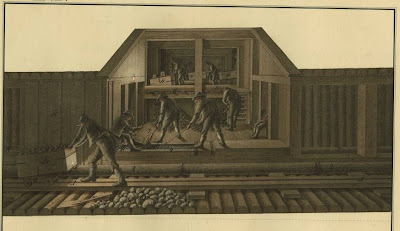
The other 2 images show views of what is considered by many to be the first recognised diving suit (Karl Heinrich Klingert , 1797). "It consists of a jacket and trousers made of waterproof leather, a helmet with a porthole, and a metal front. It is linked to a turret with an air reservoir. The reservoir cannot replenish itself, so the suit has a limited dive time duration."

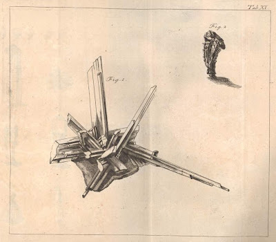

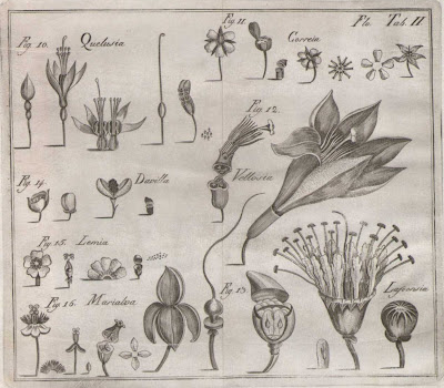
The above images come from
a selection of historical geology, mineralogy and mining books from Hungary (some are in german and some, hungarian). I know the first image comes from
'Fichtel - Beytrag zur Mineralgeschichte von Siebenbürgen 1-2.Nürnberg, 1780'.

'Slaying the Big Bear and the Sea Monster' - 1883
This is a satire about the impeachment of the incumbent political heavyweights, the founder of Mitsubishi and the largest Japanese ship owner by politicians from a rival party. (somewhere in the
Kosho section at Waseda University)


The Tahitian jungle scenes and maps of Tahiti and Hawaii come from
'Narrative of the United States Exploring Expedition During the Years 1838, 1839, 1840, 1841, 1842. By Charles Wilkes, U.S.N. Commander Of The Expedition, Member Of The American Philosophical Society, Etc. In Five Volumes, And An Atlas. Philadelphia: Lea & Blanchard. 1845.'And at the time of posting this I've found that the Smithsonian Institution has a large web exhibition devoted to the expedition (
'The United States Exploring Expedition, 1838-1842') but they have posted their maps in greyscale so the above images are better in my opinion, despite the age related damage.

'The cacina, a sacred dance, at the Zuni Pueblo, New Mexico'
IN:
'Report upon United States Geographical Surveys West of the One Hundredth Meridian, in charge of Capt. Geo. M. Wheeler, Corps of Engineers, U.S. Army' 1875-1889.
The Tahiti/Hawaii and Native American images are part of the new upload (>1000 images) to the
David Rumsey Historical Map Collection (via:
The Map Room).

From:
'Description des octants et sextants anglois, ou quarts de cercle a reflection, avec la maniere de servir de ces instrumens, pour prendre toutes sortes de distances angulaires, tant sur mer que sur terre : précédée d'un mémoire sur une nouvelle construction de ces instrumens; et suivie d'un appendix, contenant la description et les avantages d'un double-sextant nouveau' (1775) - João Jacinto de Magalhães.


From:
'O engenheiro portuguez..' in 2 volumes (1728, 1729) by Manuel de Azevedo Fortes.


From:
'Diccionario dos termos technicos de historia natural extrahidos das obras de Linnéo..' by Domenico Vandelli 1788.
There is an extensive selection of
historic science monographs from Portugal at the University of Porto's Faculty of Science. It's a great site with thumbnail views. (probably via
Archivalia)
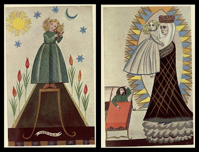


From the Polish childrens' book
'Treny' with illustrations by Zofia Stryjenska from 1930 (accompanying 16th century poetry by Jan
Kochanowski).

From:
'Heraldica to iest osada kleynotow rycerskich y wiadomosc znakow herbownych' by Józef Aleksander Jabłonowski, 1772.
[These 2 Polish books were found somewhere among
the extensive and exceptional Digital Library of Poland]


This (truncated and spliced) image depicts half-buried statues from Cornelis de
Bruijn's 1718 book
'Voyages de Corneille le Brun par la Moscovie, en Perse, et aux Indes Occidentales'. The statues are from the area near Persepolis (Naqsh-i-Rustam in Iran). They date to the
Achaemenid Empire (~550-330 BC).
It comes from the extensive
MAVI site (Musée Achéménide Virtuel et Interactif) which presents an inventory of the heritage relating to the historical space and time during which the Middle East from the Indus to the Mediterranean was under the control of the Achaemenid Persian empire. Many world universities are involved. I have to say that when I was playing around in this site a week or 2 ago I found it to be quite frustrating/annoying. But there is a 15 minute film in
computerspeak english that explains how to use the site, which of course I didn't watch because I'm a male. [
pdf background]

'Delight of Hearts' -
an early 17th century copy of a Persian cosmography map
by Zakariya' ibn Muhammad
Qazwini. (from
Rylands Library)

'Allegory on the death of the Earl of Arundel' by Wenceslaus Hollar.

'Aeneas in the underworld. State 2' by Wenceslaus Hollar.
The University of Toronto Libraries have a brand new and very large web exhibition of some 2,500 works by 17th century Czech-English artist, Wenceslaus Hollar. It is a fantastic site with mouseover enlargements, print categories for easy browsing and a flash zoom if the large images somehow aren't good enough.


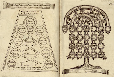
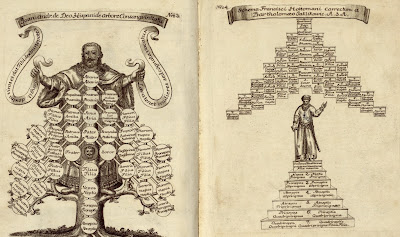
The 3 images above come from a 15th century compilation manuscript featuring the 2 major works of German humanist,
Albrecht von Eyb:
'Ehebüchlein' (The Marriage Book) and
'Spiegel der Sitten' (The Mirror of Morals). The manuscript has quite a few (what appear to be) zodiac-like vignettes through its 60 pages and is online at
Die Bayerische Staatsbibliothek. {illustrations start p26; click
'Miniaturansicht').
 The University of Hamburg
 have a number of beautiful historic maps and views of the city including the 1730 map (spliced from screencaps) above by J Covens & C Mortier.
[click everything in sight for larger versions (in most cases)]
Many of these books and illustrators could have made up material for individual posts (and may do in the future) but sometimes I just have to at least partially empty the desktop and clear my head.


